VISIT TACLOBAN: STO NINO SHRINE MUSEUM

Niño Shrine Museum.
Sto. Niño Shrine Museum


Who says you could only find castles and dream rooms in EUROPE?

The Santo Niño Shrine, one of the 29 presidential rest houses that the late Pres. Ferdinand Marcos had built. There is an Olympic sized swimming pool behind the building.

The entrance to the Santo Niño Shrine. The Santo Niño is at the far end of the entrance. On both sides are a number of guest rooms with various themes.

Santo Niño, a representation of the infant Jesus Christ, is the patron saint of Leyte.


It is located in Real Street, Tacloban City. Paintings of the 14 stations of the Cross done by Filipino artists, wooden bas-relief of the legend of the First Filipino man-woman (Si Malakas at si Maganda); tastefully decorated guestrooms of varied Filipino motifs; image of the Holy Child; a collection of original paintings by Fernando Amorsolo; spacious ballroom; priceless. collector's.

some of the must see things inside are the antiques which was brought from different places. the mirrors, the statues, the furnitures, chandeliers, and the paintings.

13-room first floor has different unique themes that is on both sides and on the center is the magnificent SHRINE, which has religious statues on it. another painting that will attract you most is the family tree of the Romualdezes.

at the back is the OLYMPIC size swimming pool and a gazebo. and on it's right is a huge LIBRARY and a function area, not just a simple function are, but a HUGE. now known as THE PEOPLE'S CENTER LIBRARY , it could accommodate large concerts and gatherings, and even GRADUATIONS and bazaars. between the two big buildings is an empty grass covered area where you will see the statue of a woman and a man (well, some folks told me it was the malakas at maganda, whose faces were copied from the couple IMELDA and FERNDINAND)

Tacloban City, is the province where the acclaimed MOST BEAUTIFUL FIRST LADY in the Republic of The Phillipines was born and raised. she became an instant celebrity during her husband's tenure in the Philippine Government serving in almost 20 years of Presidency. She lived in the most luxurious quality of living that almost all Filipina envies and was even tagged as a QUEEN.

no wonder that the whole STO NINO SHRINE, it's authenticity and beauty was taken from the owner herself, MADAM IMELDA.

now, it is owned by the city government and serves a simple history. everyone is welcome to visit the shrine and entrance fee is being collected for the EXTRAORDINARY maintenance of an EXTRA BEAUTIFULLY mansion of the MARCOSES.

EXPERIENCE RIVER CRUISE TO SOHOTON CAVES - Basey, Samar

Sohoton Caves & Natural Bridge
 

Eight hundred forty hectares nature reserve beckons with an endless array of subterranean delights, caves, natural bridge of limestone boulders, underground rivers, and weathered formation rocks like Banaue Terraces – Great wall of China – Harem Pavilion – Amphitheater with natural built in acoustical system and Seductive Courtesan’s Boudoir. Regular trips: 6:00 to 10:00 AM daily, soon a River Cruise provides total adventure to SOHOTON NATURAL BRIDGE NATIONAL PARK open to everyone who wants to reach nature by experience...

Itinerary Guide

BY AIR, the perfect way to reach BASEY daily (One Hour Manila Tacloban PAL-CEBU PACIFIC-ZEST flights, a 30-45 minutes land travel by L3 VANs/JEEPNEYS to the poblacion of Basey passing through the SAN JUANICO BRIDGE, Tacloban City, Leyte. Drop at the MUNICIPAL TOURISM OPERATIONS CENTER - Basey, Samar under the office of the Mayor which open daily from 8 AM - 5 PM for coordination of Package Tours with Transportation and Tour Guiding services to Sohoton Caves and other local destinations.

SAN JUANICO BRIDGE - Tacloban City, Leyte

San Juanico Bridge (Marcos Bridge)

Spanning 2.16 kilometers across the picturesque San Juanico Strait joining Samar Island and Leyte Island.

Longest Bridge in the Philippines

Steel structure built in 1973

during the Marcos administration

2.16 Kilometer bridge

43 Spans and 41 Meters High.


During the mid 1960's during the the Marcos administration the decision was made
to erect the San Juanico Bridge (aka "Marcos Bridge") over San Juanico Strait from
Bgy. Cabalawan, Tacloban City, Leyte,10 KM from the city proper (Leyte Capital) to
Sta Rita Municipality, Western Samar, 96 KM from Catbalogan (Samar Capital).


In 1968 the Construction and Development Corporation of the Philippines was awarded
the Contract to Design, Finance and Construct the Enormous Engineering Project.
CDCP's design and engineering staff, together with Japanese engineers, undertook a detailed survey, study and analysis and began

Construction of the Bridge Completed in 1973.


Also known as the Marcos Bridge

It is said to have been presented

as a Gift and "Testimonial of Love"

by the Philippine

President Ferdinand Marcos to the

first lady, Imelda, a native of Leyte.

MACARTHUR PARK LEYTE LANDING

McArthur Park Leyte Landing
 
Today we commemorate the 65th anniversary of the “MacArthur Leyte Landing”.

October 20, 1944: After weeks of heavy bombardment executed by American fighter planes and battle ships on the Leyte beach shores against the defending Japanese forces, the Sixth Army regiment of the combined USAFFE forces arrived at Red Beach in Palo, Leyte. By 1 PM, the combined Allied forces have established enough foothold around the beach area as well as the outskirts and terrains of Palo and Tacloban against the Japanese resistance. With a secured beachhead, the coast was cleared for the arrival of General Douglas MacArthur as he fulfilled his promise to liberate the Filipino people – in his own words, “I Shall Return”.

LAND MACARTHUR

The personalities that accompanied General MacArthur on his dramatic return on the Leyte shore were President Sergio Osmeña, General Carlos P. Romulo, Major General Basilio J. Valdes, and other key officers of USAFFE and the combined Allied liberating forces. After they arrived at around 1:30 PM, MacArthur addressed the following statement and was broadcasted nationwide via radio – “People of the Philippines, I have returned! By the grace of Almighty God, our forces stand again on Philippine soil.”

The return of General MacArthur in Leyte was a turning point of the Philippine liberation campaign during the Second World War primarily because it marked the first decisive win of the combined Allied forces against their Japanese counterparts, and secondly, it gave hope to the millions of Filipino people and the thousands of POWs as they await their freedom in the hands of the Imperial Army of Japan.

The Leyte Landing Memorial Park, formerly known as the MacArthur Park, in Red Beach Palo, Leyte was built to memorialize the “Leyte Landing” event which is celebrated annually in the Philippines on October 20.

THE LEYTE PARK RESORT HOTEL, Tacloban City – Philippines

Leyte Park Resort Hotel

Built by former First Lady, Imelda Marcos in 1979, the hotel closed for 3 years until 1994 when it reopened following renovation and refurbishing. The Resort is now a major tourism and convention complex with its 6-hectare parkland nestled on a hill overlooking beautiful San Pedro Bay. It exudes the distinctive luxury of a hotel and the ambiance of a resort.

Leyte Park Resort Hotel offers the Discovery of various eco-tourism based tour activities anchored on its marine and terrestrial beauties, that covers a wide range of destinations from "islands to highland".
Back to Top

LOCATION

The Leyte Park Resort Hotel is conveniently located in the heart of Tacloban City, 55 minutes from Manila by plane.

Road Directions/How to get to Leyte Park Resort Hotel
From Sumulong Highway facing East going to Cainta, turn left at Balanti bypass road, then left at Katipunan and right at Pio del Pilar.
Back to Top

DINING FACILITIES

Dining facilities include the following restaurants, bars and coffee shop:

Veranda Café
Located on the 2nd floor, this is the Resort's main restaurant. The ambiance evoke Philippine rusticity with a breathtaking view of the mountains and the sea. International cuisine is on the menu with preferential bias to Leyte-Samar gourmet favorites. Open daily 4:00 am up to 2:00 am.

San Pedro Bay Seafoods Restaurant
Located at the Resort Marina, this specialty restaurant serves available seafood as caught from the San Pedro Bay fronting the Resort property. Cultural presentations of Philippine and Leyte-Samar songs and dances are available by arrangement for parties. 


Lobby Sala Grill
This cozy restaurant is adjacent to the Veranda Café and specializes in grilled seafood coming in fresh from San Pedro Bay. Nightly lounge music from 7:30 pm up to 11 pm.

Food Park
Enjoy nightly @ Tacloban City's favorite watering hole. Native barbecue and other local appetizers are available. Open from 7 pm to 1 am.

Pool Patio
While having as swim or simply a dip or just lazing around. Enjoy snacks and frozen delights. Mouth-watering treat from 9 am - 12 pm.

Park Café
Discover the distinctive character of Espresso Base, Flavorful and Satisfying Coffee. The Café at an altitude with an attitude.
Back to Top

OTHER FACILITIES, AMENITIES AND SERVICES

Fitness Center
Opening Hours: 6:30 am - 9:30 am, 4:00 pm - 8:30 pm, Closed on Mondays

Gift Shop
Opening Hours: 9:00 am to 6:00 pm

Business Center
Computer & Internet Services, Photocopy, Fax, etc. Wi-Fi (Internet Wireless Connection) is available 24 hours a day. Opening Hours: 8:00 am to 5:00 pm, Closed on Sundays

Convention Center A
Have your weddings, birthdays, parties, conventions, seminars and other functions in this fully air-conditioned hall. It can accommodate 350 pax for banquets and 500 pax for theater-style arrangement.

Convention Center B
This Dome can accommodate up to 2,000 pax for large conventions, concerts and theater performances. Sports activities can also be made by prior arrangements.

Don Joseph Pavilion
The Pavilion has a built-in dance floor and can accommodate 100 pax for banquets and 150 pax theater-style arrangement. The Hall is fully air-conditioned.

President's Hall
Ideal for small receptions of up to 70 pax. The Hall is fully air-conditioned. Overlooks the panoramic view of Mount Danglay and the beautiful San Pedro Bay.

GUIUAN'S TREASURE CHEST, NATURAL WONDERS

 
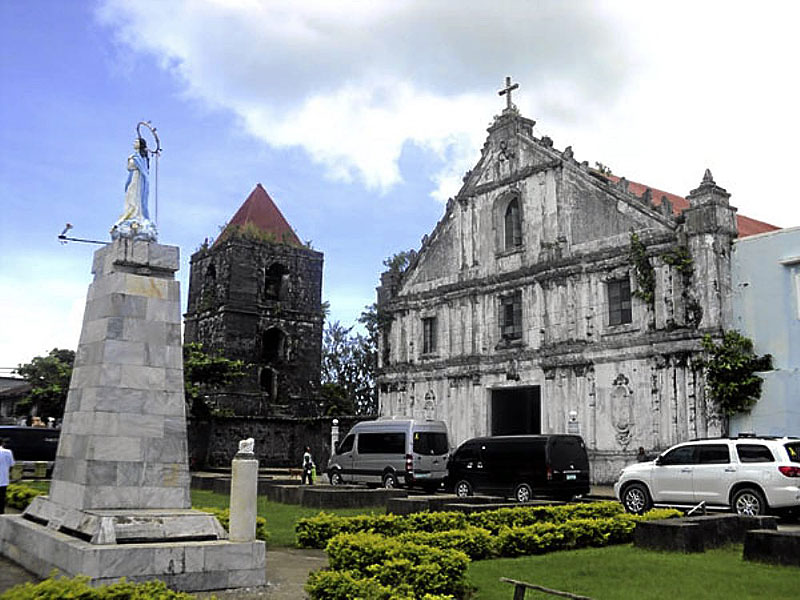
THE 16TH CENTURY church of Guiuan, Eastern Samar, and its belfry.

GUIUAN, Eastern Samar—Perhaps no other place in Eastern Visayas has been endowed with so much tourist attractions than the ancient town of Guiuan in Eastern Samar. Not only is it rich in history and culture but it also boasts of many natural wonders.
Thus, when Tourism Secretary Alberto Lim visited the province last month, he was impressed by what he saw in Guiuan: “a long white beach which can rival other beaches in the Philippines.” It has all the elements of a tourist come-on, he added.
Among Guiuan’s “treasures” is the 16th-century Immaculate Conception Church at the town proper. Originally made of wood, the structure was rebuilt by the priests and natives using stones after it was razed by fire.
It is within a 42-square-meter fortress, its corners mounted with artillery.
At that time, it was “the best and most regularly planned in all the Visayas” and that it “exceeds in grandeur the celebrated fort in Zamboanga.” But with the passage of time, the walls were destroyed.
Most of the church, including its belfry is still preserved, however.

National treasure

SHELL embellishment can be seen inside the baptistry of the church. 

According to Prof. Eric Zerrudo, an expert on cultural heritage and museum development, the Guiuan church has been declared a “national treasure church”—one of only 26 in the country.
“Guiuan, had there been a chance, should have been catapulted to a world heritage level. Why? It has a very high authenticity. Everything here is original. Everything has been left intact; (only) very few interventions,” Zerrudo says.
The church has a main altar and two altars along the nave. One has a retablo built by the Franciscans while the other has a rococo frontal built by the Augustinians.
Shell embellishments are seen in the baptistry, side altars, side windows and niches. Zerrudo says the shell craft tradition dates back to the 16th century and has continued up to now. In Sulangan, a pilgrimage site in Guiuan, the altars are similarly adorned.

Second class
Located in the southernmost tip of Eastern Samar, Guiuan has a land area of 17,549 hectares and a population of about 45,000. A second-class municipality (annual income: P45 million to P55 million), it has 60 barangays, including the islands of Tubabao, Calicoan, Sulangan, Homonhon and Suluan.
It is 109 kilometers away from the provincial capital of Borongan City and 155 km from Tacloban City, the regional capital.

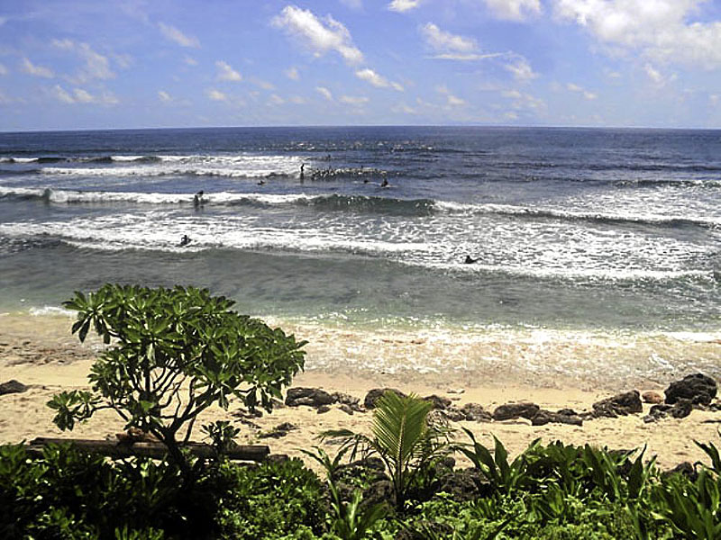
A SURFING area on Calicoan Island in Guiuan. 

On Nov. 10, 1978, Proclamation No. 1801 was signed declaring Guiuan a “tourist zone and marine reserve” under the administration and control of the Philippine Tourism Authority (PTA).
It was in Guiuan where Portuguese navigator Ferdinand Magellan and his men, sailing under the flag of Spain, first set foot on Philippine soil after crossing the vast Pacific Ocean—on the shore of Homonhon Island on March 16, 1521. The event was later marked as the “discovery” of the Philippines.
In 1944, the Americans arrived in Guiuan and built a military base for its torpedo boats, warships, bombers and fighter planes that were involved in the Philippine liberation campaign and in the invasion of Japan. About 100,000 American servicemen were stationed in Guiuan and nearby towns.
The base was the biggest American supply base in the Pacific during the war.

Russian refugees

In 1949, about 5,000 Russians escaping from communist rule in China made Guiuan their home for 27 months.
With the help of the International Refugee Organization, they sought refuge on Tubabao Island until 1951 when they moved to Australia and the United States.
Mayor Annaliza Gonzales-Kwan says tourists usually frequent the paradise island of Calicoan, which has a 12-km stretch of white beach and a world-class surfing area.
Calicoan was declared by then President Gloria Macapagal-Arroyo as the “Surfing Capital of the Visayas.” What is unique about the island, the mayor says, is that the side facing the Pacific Ocean has big waves which is ideal for surfing. The side facing the Leyte Gulf has calm waters suitable for swimming and boating.
The 1,600-hectare Calicoan also has a lush forest with abundant wildlife, such as monkeys and monitor lizards, six lagoons and some caves.

Tourist activities

Tourists can go surfing, swimming, kayaking, trekking, spelunking or island hopping and enjoy the white beaches of Suluan and other islets.
Aurora delos Reyes, municipal investment, environment and tourism officer, says at least 3,000 tourists have visited Guiuan in the first quarter. “Many visitors come here to surf,” she says.
More are expected once the airport becomes fully operational. It is the same facility built by the Americans in 1944 and is now undergoing rehabilitation.
Guiuan has been a consistent winner in the Clean and Green contest in Eastern Samar since 2004. It has been adjudged Best Managed LGU (local government unit) in the province.
Delos Reyes says the municipality has also been the best LGU One Town One Product (Otop) implementor on the provincial and regional levels and a finalist on the national level.
One of its products: Ecotourism.

TOURIST PARADISE REDISCOVERED


RIYADH: Philippine tourism has been a top-dollar earner for the country, propping up the country's dollar reserves. 
The Department of Tourism (DOT) expected a 15-percent growth of tourist arrivals in the top destinations of the country for this year.
This reflects the efforts of the DOT to promote tourism and shows the kind of tourist attraction in the Philippines.
For this reason, tourists have been exploring the country, taking a peek at Filipinos' history and culture mirrored by the century-old churches, ancient forts and modern museums.
“Discover the Philippines. Blessed with an extensive coastline, the Philippines is ringed with unspoiled beaches and first-class resort facilities. Its deep-blue, crystal clear waters offer about 40,000 sq km of coastline of coral reefs teeming with a wide variety of marine life,” the DOT statement says.
Endowed with temperate climate, the Philippines offers a perfect treat. Lying in southeast Asia and surrounded by the Pacific Ocean, the Philippines boasts unsullied beaches, spectacular sunsets, luxuriant pastoral lands, cool mountain weather, brilliant man-made resorts and dazzling islands.
The Philippines boasts some of the best beaches and scuba diving waters in the world, supported by golf and an increasingly impressive inter-island tour and transport system.
Witness the vast expanse of nature's splendor under the spell of cool mountain breeze. It is a perfect setting for romance or nature tripping and the country's mountain villages serve as a perfect hideaway from the lowland's summer heat.
If you have yet to see the Philippines, then embark now to what promises to be a trip to paradise. Feel the breeze of summer at white-sand beaches deemed as among the world's finest; be fascinated at the spectacular view of Baguio and Tagaytay; and take a dip in the refreshing waters of modern resort facilities.

SAMAL ISLAND

Samal island offers an unending fascination with its white-sand beaches, thick mangroves, coral reefs, rolling hills and rock formations. It is an archipelago of nine islands located in the Davao Gulf about 700 meters south of Davao City. An ideal model for resort and development, it provides a fabulous site for sunrise and sunset. Samal Island, like the rest of Mindanao, is outside the typhoon belt, and enjoys relatively calm weather. Its coastline is characterized by tall, swaying coconut trees, white-sand beaches, rock formations, mangroves, coral reefs, and small fishing villages — all suggestive of a tropical paradise.

Almost all of the beach areas have white sand, with widths varying from only a few meters to more than 10 meters. It provides ample space for picnic huts, reclining chairs for sun bathing, or for simply relaxing and enjoying the tropical scenery.

The water is crystal clear throughout the coastline, which varies in terrain from gently sloping sand beaches to steep cliffs and rock formations. The colors of the coastline at the beach areas transform itself from the green lush vegetation of coconut trees, to the white sandy beaches, to the dark blue color of the sea, with its deep waters and coral reefs.

BOHOL'S SPRING AND BEACHES

Bohol is one of the loveliest islands in southern Philippines. It is situated at the heart of Visayas and with coastline skimmed by gentle coves and white-sand beaches. Many highways snake along the sparkling beaches or leafy rivers where one can stop at any point and jump in.
With its rolling hills and plateaus, crystal springs and beaches, Bohol is a picturesque province replete with ancestral homes and centuries-old churches. It is composed of numerous isles  — Panglao, Pamilacan, Cabilao, Jao, Mahanay and Lapinin. The Chocolate Hills are but some of the many natural wonders in the province, which is home to the world's smallest monkey, the tarsier. The size of a fist, the tarsier lives on the hills of Corella, some 10 km from Tagbilaran. Other exotic flora and fauna may also be found in the forests of Bohol Island.

LAGUNA DE BAY (LAKE BAY)

LUZON, PHILIPPINES
Laguna de Bay (Lake Bay) is often erroneously called the "Laguna Lake". It is the largest lake in the Philippines. On the lake, there are an island, Talim, and two peninsulas jutting out a long way from the north coast. The lake is considered to have once been a branch of Manila Bay but later became separated from the bay by volcanic deposits and the upheaval of land. Water flows out from the northwestern end of the lake to Manila Bay. Since, the difference of water level between the lake and the sea is so small, the adverse tides occur frequently during the dry season from January to April.
Photo.Vast paddy fields, sugar cane fields and coconut plantations spread over the alluvial plain around the lake. Cash products like vegetables, fruits and poultry are also raised for consumption in neighboring big cities as Manila and Quezon City. The Laguna Lake Development Authority established in 1970 is mainly responsible for promoting development and conservation works in the lake and its drainage basin

MANILA DE BAY

MANILA CITY, PHILIPPINES


View of the famous Manila Bay Sunset from the Bay City in Pasay (near SM Mall of Asia)
The bay is considered to be one of the best natural harbors in Southeast Asia and one of the finest in the world. It has an area of 1,994 km2 (769.9 sq mi), and a coastline of 190 km (118.1 mi). The entrance is 19 km (11.8 mi) wide and expands to a width of 48 km (29.8 mi).Corregidor Island divides the entrance into two channels, about 2 miles (3.2 km) towards the North and 6.5 miles (10.5 km) wide on the South side. Mariveles, in the province of Bataan, is an anchorage just inside the northern entrance and Sangley Point is the former location ofCavite Naval Base.
On either side of the bay are volcanic peaks topped with tropical foliage: 40 km to the north is the Bataan Peninsula and to the south is the province of Cavite.
Across the entrance to Manila Bay are several islands. The largest is Corregidor, which is 3 kilometers from Bataan and, along with the island of Caballo, separates the mouth of the bay into the North and South Channels. In the south channel is El Fraile Island and outside the entrance, and to the south, is Carabao Island. El Fraile, a rocky island some 4 acres (1.6 ha) in area, supports the massive concrete and steel ruins of Fort Drum, an island fortress constructed by the United States Army to defend the southern entrance of the bay. To the immediate north and south are additional harbors.
The bay was the setting for the Battle of Manila Bay in 1898 and the siege of Corregidor Island by invading Japanese forces in 1942.
Manila Bay drains approximately 17,000 km2 (6,563.7 sq mi) of watershed area, with the Pampanga River contributing about 49% of the freshwater influx. With an average depth of 17 m (55.8 ft), it is estimated to have a total volume of 28.9 billion cubic meters (28.9 cubic km). Today, Manila Bay still remains important for commerce and industry, including fishing, although rapid urban growth and industrialization are contributing to a decline in water quality and deteriorating marine habitats. It also serves a focus for recreation for Metro Manila and is a popular destination for walks and for viewing the sunset. Much of the land fronting the bay along Metro Manila is reclaimed land which now includes important sites such as the Philippine Senate and the Mall of Asia.

SIARGAO ISLAND

SURIGAO DEL NORTE, PHILIPPINES


Surigao del Norte is a medley island in the northeastern tip of Mindanao. A province that has managed to preserve its natural marvel through the years. On the eastern side of the province is Siargao Island, a hidden tropical jewel of the Pacific that hosts one of the most beautiful beaches in the world and home of wave surfing and the famous CLOUD 9, the latest sport and tourist attraction to take the country by storm It is the Surfing Capital of the Philippines. The best known surfing break now with a world reputation of being in the top Surfing Waves in the world, is nick-named "Cloud Nine". But there are literally scores of breaks down this coast, and every time a surfing expedition is mounted in the area, more new breaks are being discovered.

Siargao is a tear-drop shaped island situated 800 kilometers southeast of Manila in the province of Surigao del Norte. It has a land mass of approximately 437 kilometers. It has a land mass of approximately 437 kilometers. The east coast is relatively straight with one deep inlet-Port Pilar with a coastline marked by a succession of reefs, small points and white sandy beaches. There are similar neighboring islands and islets with similar landforms. The reefs and points are excellent for picking up any swell that comes along turning into clean, fast waves. The Island's Pacific-facing reefs are situated on the edge of the Philippine Trench, and the extremely deep offshore waters guarantee the ocean swells have undiluted power when they encounter the many coral and rock reefs, giving Siargao excellent surfing conditions, particularly during the southwest "habagat" monsoon from August to November, when the prevailing wind is offshore.


 Siargao Island, faces the Pacific Ocean and the Philippine Deep, the second deepest water in the world, at more than 11 km below sea level. The area is pure tropics with the plenty activities including snorkeling, island hopping, waterfalls, swimming holes and of course awesome waves and friendly locals.

This right-breaking reef wave is the site of the annual Siargao Cup, a domestic and international surfing competition sponsored by the provincial government of Surigao del Norte. The wave was discovered by travelling surfers in the late 1980's, and named and made well-known by American photographer John S Callahan, who published the first major feature on Siargao Island in the US based SURFER Magazine in March 1993, and hundreds of photos in many other books and magazines since. Callahan has returned to the island many times since his first visit in 1992, and his efforts to photograph and publish surfing related and general location material from Siargao islandin books and magazines around the world has put the island on the international map and drawn thousands of surfers and tourists to Siargao island.

 There are several other excellence waves on Siargao and nearby islands, but Cloud 9 has received more publicity than any other wave in the area, indeed in the Philippines as a whole. It is the only wave in the area easy to get to without a boat, leading to overcrowding and the nickname of "Crowd 9" among surfers worldwide as keen foreign and locally owned accommodation and tourist facilities attempt to profit from the magazine publicity and the annual arrival of visitors drawn by the Siargao Cup competition in September.

Siargao Islands contain the biggest mangrove forest reserves in Mindanao on the opposite coastline. Long stretches of wetlands equally indicate potentials for commercial seaweed propagation. Siargao Island is greatly influenced by the winds and currents coming uninterrupted from the Pacific Ocean, intensified by the Mindanao current running westward through the Siargao Strait.
Offshore, a classic tropical island lay secluded within its surrounding coral reef and the dozen coconut palms dressed in the center circle of the island crackle gently in the morning breeze. Off to the right, well within the massive coastal reef, lay a shining white sand bar some 200 meters long, maintained by a group of some forty black-headed terns that stood chattering among themselves at the waters edge. The tide of Siargao is diurnal with tidal curves typically present especially on the east coast of the island.

Siargao Island

The newly discovered island boasts of white-sand beaches and surfing waves compared to that of Hawaii. Lying 800 km southeast of Manila, the ear-shaped Siargao island is a perfect haven for sun, seas and surf buffs. It lies on the eastern portion of Surigao del Norte and on the southeastern tip of Mindanao. The island is a mass of tropical land and scores of reefs, points and white-sand beaches.

100 ISLANDS

PANGASINAN, PHILIPPINES


The Philippines Hundred Islands Park is composed of big and small islands surrounded by fresh and salty water. Over 123 islands with an area of 1,1884 hectares. The hundred islands is located in Pangasinan one of Philippines provinces in North Luzon. It is one of the Philippines beautiful spots for tourism. 


 This is one of the visited places in the country when it comes to beaches and resorts. The islands are really amazing. It looks like they cast down purposely. The other perfect place to relax and enjoy the vacation. "The Top 10 most beautiful place to go" declared by the Manila Bulletin one of the leading news papers in the country.


It was December 23rd when I and my friends decided to go there. I was very excited because it would be my first time to go there.  When we got there, I really surprised. I exhaled and absorb the cold air coming around.
Everyone is excited. After the day, we were all exhausted. By the way, I'm just sharing our experience being there.

You can rent boats to hang around real amazing nature. You can stay there and enjoy the vacation without spending a lot of money. All accommodations are very affordable. So nothing to worry about.

BAGUIO AND BANAUE RICE TERRACES

IFUGAO, BAGUIO, BENGUET, PHILIPPINES


The Banaue Rice Terraces of the Philippines have been said to be like the 8th wonder of the world. They were carved from the hillside by the tribes people of Ifugao about 2,000-3,000 years ago. The tribes people did this with their bare hands and crude implements, without using machinery to level the steps where they plant their rice, which is what makes this wonder so attractive, aside from the fact that the rice terraces are still used today.
This is considered to be one of the greatest engineering feats of mankind, because if each one were connected end to end, then they would reach halfway across the globe or be 10 times as long as the Great Wall of China. It was not until only 13 years ago (1995) that the Banaue Rice Terraces were declared a World Heritage Site by UNESCO.
The rice terraces are like stepping stones stretching towards the sky, where some of them reach almost 5,000 feet in altitude and cover about 4,000 square miles of land. They are now beginning to show signs that they are eroding, and some of them need maintenance, while the Ifugaos’ new generation is migrating to nearby cities in search of better opportunities.
Even though it is about 8 or 9 hours from Manila in a car, the Banaue rice terraces are known to be one of the most spectacular places to see in the Philippines. They have transformed the Cordillera mountains of barren stone into ledges that are fit to grow rice.


Baguio City and Rice Terraces

Rising 1,500 meters above the sea, Baguio City enjoys a relatively cool weather throughout the year. Baguio City is at least eight degrees cooler than any place in the lowlands. Not surprisingly, Baguio City has become the “summer capital of the country.”

It is endowed with a variety of cultural, historical and scenic attractions that make it an important and interesting destination. As early as March, tourists and locals take the six-hour trek up the zigzagging Kennon Road. Within the city, the sweet scent of pine trees and flowers already permeate the air.

Designed by Daniel Burnham during the American occupation, Baguio City is situated in the midst of pine-covered hills.

Having visited Baguio City, a tourist should not miss the historic and breathtaking Banaue Rice Terraces that is also known as one of the wonders of the world. The terraces planted to rice remains to be a wonder among local and foreign tourists. 

THE CHOCOLATE HILLS

BOHOL, PHILIPPINES


The Chocolate Hills, maybe Bohol's most famous tourist destinations. They look like giant mole hills, or as some say, women's breasts, and remind us of the hills in a small child's drawing. Most people who first see pictures of this landscape can hardly believe that these hills are not a man-made artifact.

However, this idea is quickly abandoned, as the effort would surely surpass the construction of the pyramids in Egypt. The chocolate hills consist of are no less than 1268 hills (some claim this to be the exact number).

They are very uniform in shape and mostly between 30 and 50 meters high. They are covered with grass, which, at the end of the dry season, turns chocolate brown. From this color, the hills derive their name. At other times, the hills are green, and the association may be a bit difficult to make.

SAN JUANICO BRIDGE

TACLOBAN CITY LEYTE, PHILIPPINES


Asia's Longest Bridge - Leyte and Samar: Eastern Visayas, Philippines

Tacloban City link Sta. Rita, Samar

Built over the narrow San Juanico street, the San Juanico Bridge–which is 2.16 kilometerslong–still holds the record as the longest bridge in the Philippines.
The bridge connects Tacloban City on the Leyte side and the town of Sta. Rita on the Samar side. It crosses the San Juanico strait, reportedly the world’s narrowest since it’s only two kilometers wide at its most narrow point. Constructed in 1973 during the administration of the late President Ferdinand Marcos, the bridge is supported by 43 spans that rise 41 meters above the sea. The views from the bridge are fantastic and include the islets near the bridge as well as the strait’s thousand whirlpools.
The 34-year-old steel structure is just 10 minutes away from the Tacloban City center. It is accessible by jeepney, bus, motorcycle, or private vehicle. There are daily flights from Manila to Tacloban City. From Cebu, the best way to get to Tacloban would be to ride on a fast boat, such as the Supercat fast craft, to Ormoc City and then take a van for hire from Ormoc to Tacloban, which is about two to three hours away.
The San Juanico Bridge, formerly the Marcos Bridge, is a Compression arch bridge in the Philippines stretching from Samar to Leyte crossing theSan Juanico Strait. It is part of the Pan-Philippine Highway. It is the longest bridge in the Philippines with a length of 2.16 kilometers (1.34 mi) [1] and is considered one of the most beautifully-designed bridges in Philippines.[2] The bridge is supported by 43 spans rising 41 meters above the sea.[1] It has a large arch beneath which allows boats to pass. Connecting Tacloban City on the Leyte side and Santa Rita town on the Samar side, it offers many picturesque views, especially of the San Juanico Street with its thousand whirlpools as well as the islets of the province. It is approximately 10 minutes from downtown Tacloban City and is accessible by passenger jeepney, bus, motorcab or private vehicle. Construction on the 21.9 million-dollar bridge began in 1969 and was completed in 1973, during the presidency ofFerdinand Marcos.[3] The Construction and Development Corporation of the Philippines (now the Philippine National Construction Corporation) was contracted to construct the actual bridge, and together with Japanese engineers, conducted studies and designed the actual project.[4] The Leyte & Samar Links by means of Trading and Transportation...
 

SURF CAMP CALICOAN ISLAND

SAMAR, PHILIPPINES


Guiuan, Eastern Samar
An idyllic tropical get away situated in ABCD Beach - Calicoan Island’s prime surfing area with landscape of virgin tropicalforests, unspoiled white sand - crystal clear water. Resort features an infinity pool fronting Pacific Ocean and 
luxurious cottages
fully equip with amenities needed by travelling public.

MACARTHUR PARK

PALO, PHILIPPINES

MacArthur Landing Memorial is situated in Red Beach, Palo, Leyte. The monument marks the spot where General Douglas MacArthur landed with the American Liberation Forces in October, 1944 starting the Battle of Leyte.

The Battle of Leyte in the Pacific campaign of World War II was the invasion and conquest of Leyte in the Philippines by American and Filipino guerrillas forces under the command of General Douglas MacArthur, who fought against the Imperial Japanese Army in the Philippines led by General Tomoyuki Yamashita from 17 October 1944 to 31 December 1944. The battle launched the Philippines campaign of 1944-45 for the recapture and liberation of the entire Philippine Archipelago and to end of almost three years of Japanese occupation.


BORACAY ISLAND

BORACAY, MALAY, AKLAN,  PHILIPPINES


Accommodation in Boracay 
Plan your vacation withBudget hotels and guest houses for inexpensiveaccommodation in BoracayMid-Range Hotels offer extra facilities and services for a more pampered vacation, with reasonable rates. In the Top End, you will find special places whereluxury and location combine to provide a truly memorable experience. You will find a variety of Boracay resorts and hotels to choose from native island style hideaways, to more exclusive high class vacation retreats. 
Boracay Tours and Activities

Tourists from all over the world are attracted to Boracay by the renowned white sand beaches and their underwater marine splendour. Of late, marine sports on the island have become a popular pasttime, and as the resorts and hotels in Boracay have become much more of an international standard.

The island is a wonderful respite from a busy metropolitan pace. In the following sections, we have attempted to give you a brief synopsis of Boracay's attractions and the many fabulous Boracay tours that can be enjoyed, including windsurfing and kitesurfing.
Restaurants in Boracay

Boracay is a great place to experience a smorgasbord of dining choices. The island has a wide variety of food to offer, even to the traveler with a discerning palate. There are four miles of beachfront restaurants in Boracay, offering every kind of food you can imagine from Thai, Japanese, Chinese, Indian, Italian, Spanish, Mexican, French, German and Korean, to the local Filipino fare.

Food and Cuisine in Boracay

Drinks & Party Scene in Boracay

Boracay has a thriving nightlife, with lots of bars and restaurants to choose from. The more noisy bars are located around boat stations 1 and 2, where you can spend the whole night partying away. Boat station 3 is quieter and more relaxed and is quite popular with Boracay regulars and longstayers. It has small local eateries and bars dotting the area, offering a laidback alternative to the hectic pace of the former locations.

Transportation in Boracay: Boracay is located in the Aklan province, easily reachable from Caticlan by ‘banca' (or pump boat). You can fly directly into Caticlan from either Cebu or Manila but flights can becheaper into Kalibo, from there you can transfer to Caticlan by taxi or bus.

By Air
Fly to Caticlan, which is the nearest airport. From Caticlan Airport, most hotels usually provide transfer services all the way to the resort for a fee, although some are included. This would include the short ride from the airport to the seaport aswell as the ride on the outrigger boat to the island itself. If you don't have such an arrangement, you can take a tricyle or walk the short distance from the airport to the seaport and catch an outrigger boat ride from there.

Airline Carriers from Manila to Caticlan
Asian Spirit/Corporate Air/Interisland Airlines/South East Asian Airlines (SEAir)

Cebu pacific /Philippine Airlines

Airline Carriers from Manila to Kalibo:
Cebu Pacific/Philippine Airlines

Air Philippines/Asian Spirit

By Boat
MBRS shipping lines (Nature Adventure Travel and Tours Hotline number 053-321-6333 operates a ferry between Manila and Caticlan. Call for the latest schedules and fares.
By Bus (or RORO)
The RORO (Roll-On Roll-Off) a combination of bus and ferry for one fee) Philtranco and Bachelor Express run bus routes on the Strong Republic Nautical Highway. From Cubao or Pasay in Metro Manila, buses run to Batangas Port about 2 hours south of Metro Manila. Ferries take the buses across to the Calapan Port on Mindoro.

Boracay Island

Widely-known as one of the finest swimming destinations in the world, Boracay is blessed with unsullied fine talcum powder-sand beaches. Its tranquil crystal clear waters are perfect for swimming, sailing, fishing and sunbathing. Boracay also boasts sapphire seas and spectacular sunsets. Countless coves dot the island and tall coconut trees line up along the beaches.
Boracay lies at the northwest tip of Panay, in the west Visayas region, off the Sibuyan Sea. The island is made up of little communities: Yapak in the north, Balabag in the middle, and Manocmanoc in the south. Hilly elevations up to 100 meters above sea level characterize Yapak and Manocmanoc. Intertwining trails link the small villages together but many sometimes lead to lush tropical jungles.